Ukraine: Where and what happened? :
-The University of Tokyo researchers convey it on a digital map-
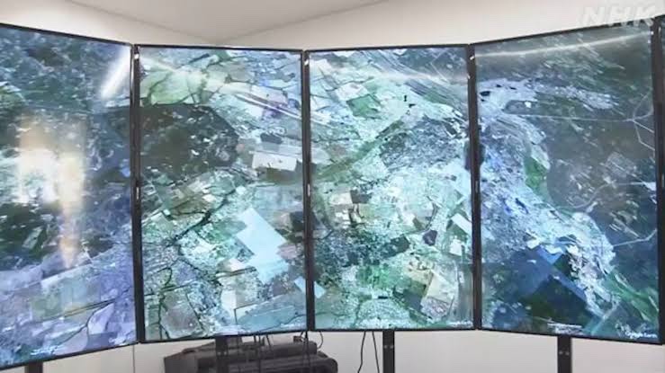
Digital map:
Researchers at the University of Tokyo, such as satellite images showing damage,
We analyzed location information and created a “digital map that tells where and what happened.”
Published on the Internet:
The map has been published on the internet.
I want you to use it as a “clue to know more about the damage that is happening now.”
University of Tokyo Graduate School
Professor Hidenori Watanave Research Team
American companies, etc.
Collects satellite images delivered daily and videos taken locally.
Determine the exact position,
I made a “digital map that tells where and what happened in Ukraine”.
Accurately grasp the damage: and
Many images showing the damage have been published so far.
However, “it is difficult to figure out exactly where it is.”
Posted on the website:
About the 180 satellite images collected
From the direction of shadows and the characteristics of the terrain,
Detailed shooting locations are specified and posted on the website.
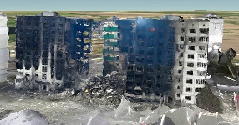
The damage was reproduced three-dimensionally with a 3D image based on the images taken with the drone.
Reproduced in 3D image:
A damaged condominium in Borojanka, northwest of Kyiv.
You can see the seriousness of the damage, such as “The first floor to the top collapses and the flames rise from the room.”
Identify the position of the Russian army:
In addition, the location of Russian military vehicles and fighters is also identified on the map.
You can also see the situation of the Russian invasion.
By reconsidering it as a line or surface instead of a point,
You can see what is happening in real time.
NHK | IT / Internet
https://www3.nhk.or.jp/news/html/20220413/k10013579521000.html
Україна: де і що сталося? :
-Дослідники Токійського університету передають це на цифрову карту-
Цифрова карта:
Дослідники з Токійського університету, наприклад, супутникові знімки, що показують пошкодження,
Ми проаналізували інформацію про місцезнаходження та створили «цифрову карту, яка розповідає, де і що сталося».
Опубліковано в Інтернеті:
Карта опублікована в Інтернеті.
Я хочу, щоб ви використали це як «підказку, щоб дізнатися більше про шкоду, яка зараз відбувається».
Вища школа Токійського університету
Дослідницька група професора Хінорі Ватанавеамериканські компанії та ін.
Збирає супутникові зображення, що доставляються щодня, і відео, зняті локально.
Визначте точне положення,
Я зробив «цифрову карту, яка розповідає, де і що сталося в Україні».
Точно сприйняти пошкодження: і
Наразі опубліковано багато зображень, які показують пошкодження.
Однак «важко зрозуміти, де саме воно».
Опубліковано на сайті:
Зібрано близько 180 супутникових знімків
З огляду на напрямок тіней і характеристики місцевості,
Детальні місця зйомок уточнюються та розміщені на сайті.
Пошкодження було відтворено тривимірно за допомогою 3D-зображення на основі зображень, зроблених за допомогою дрона.Відтворено в 3D-зображенні:
Пошкоджений ОСББ у Бороянці на північний захід від Києва.
Ви можете побачити серйозність пошкодження, наприклад «Перший поверх до самого верхнього обвалюється, і полум’я піднімається з кімнати».
Визначте позицію російської армії:
Крім того, на карті також визначено розташування російської військової техніки та бойовиків.
Ви також можете побачити ситуацію російського вторгнення.
Переглядаючи його як лінію або поверхню замість точки,
Ви можете бачити, що відбувається в режимі реального часу.NHK | IT / Інтернет
3D data & 360 panoramas Map of Ukraine | Cesium Stories
https://cesium.com/ion/stories/viewer/?id=f3d06daa-ad24-418e-9d80-7764869554aa
Japanese researchers create digital map of Ukraine destruction
The researchers identified locations shown in about 180 of the images by analyzing landscapes and the directions of shadows.
The video used included drone shots and was used to create three-dimensional images of damaged structures.
One of them depicts the serious damage of an apartment building in Borodyanka, northwest of the capital Kyiv.
It shows part of the building has collapsed from top to bottom, while the inside of a room is burning.
The map also shows the locations of vehicles and fighter jets of Russian forces.
NHK WORLD-JAPAN News