JOGMEC: Secure Japan’s Vital Minerals!
1. Explore for rare earth elements and important minerals lying dormant in Japan’s EEZ!
2. Infiltrating Japan’s marine resource research vessel “Hakurei”
Breaking news from an article published in the METI Journal.
Japan is a leading maritime nation, ranking 6th in the world in terms of the area of its territorial waters and EEZ.
1. The combined area of Japan’s territorial waters and EEZ is 4.47 million square kilometers, 12 times the land area (approximately 380,000 square kilometers).
2. While Japan ranks 61st in the world in land area, it ranks 6th in the total area of its territorial waters and EEZ.
Including the “extended continental shelf,” where geological and topographical continuity is recognized, the area reaches approximately 4.77 million square kilometers.
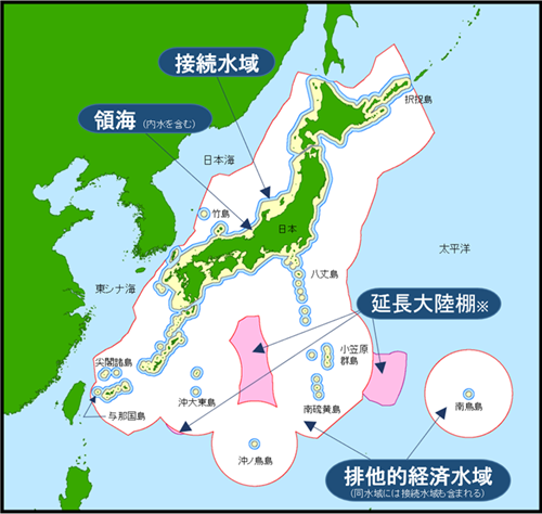
Conceptual Diagram of Japan’s Territorial Waters, etc.: Japan Coast Guard Website
Marine minerals distributed in the sea areas around Okinawa, Izu-Ogasawara, and Minamitorishima are classified into four types:
“Seafloor hydrothermal deposits,” formed by the precipitation of metal components such as copper and zinc contained in hydrothermal fluids erupting from the seabed, as they cool.
1. “Cobalt-rich crust,” a thin layer of manganese oxide covering the surface of seamount slopes and peaks.
2. “Manganese nodules,” distributed on the seabed and containing copper, cobalt, and other elements.
3. “Rare earth mud,” a clay-like sediment containing high concentrations of rare earth elements beneath the seabed.
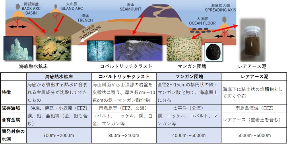
Types of Marine Mineral Resources:
Promising seafloor hydrothermal deposits are located in the sea area around Okinawa.
They are attracting attention due to their high grade of cobalt, which is essential for the manufacture of lithium-ion batteries.
Cobalt-rich crust and rare earth mud have been confirmed to exist in the Minamitorishima sea area.
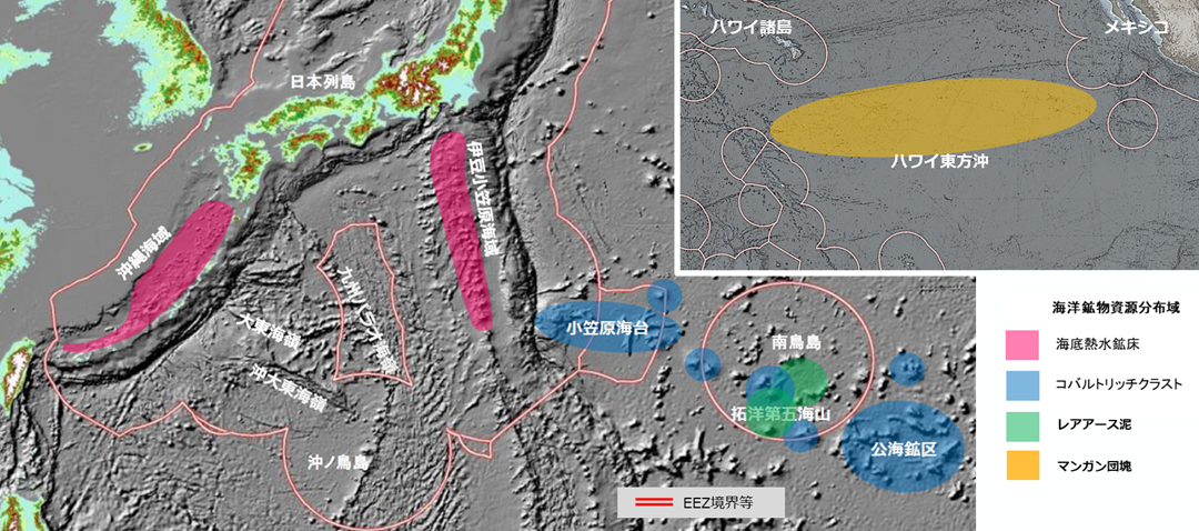
Distribution Status of Japan’s Mineral Resources: Valuable Domestic Resources:
1. Japan’s marine policy is based on the Basic Act on Ocean Policy and the Basic Plan on Ocean Policy.
2. Formulated by the Ministry of Economy, Trade and Industry as the “Ocean Energy and Mineral Resource Development Plan.”
“Ocean Energy and Mineral Resource Development Plan”:
3. In Japan’s seabed hydrothermal deposits, a total of 51,805,000 tons of resources have been found in seven deposits.
4. Furthermore, seven new deposits have been discovered in the waters off Okinawa and the Izu-Ogasawara Islands.
For cobalt-rich crusts, drilling surveys will be conducted in the Ogasawara Plateau and off Minamitorishima Island.

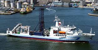
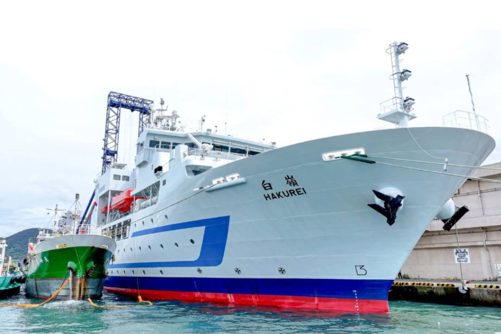
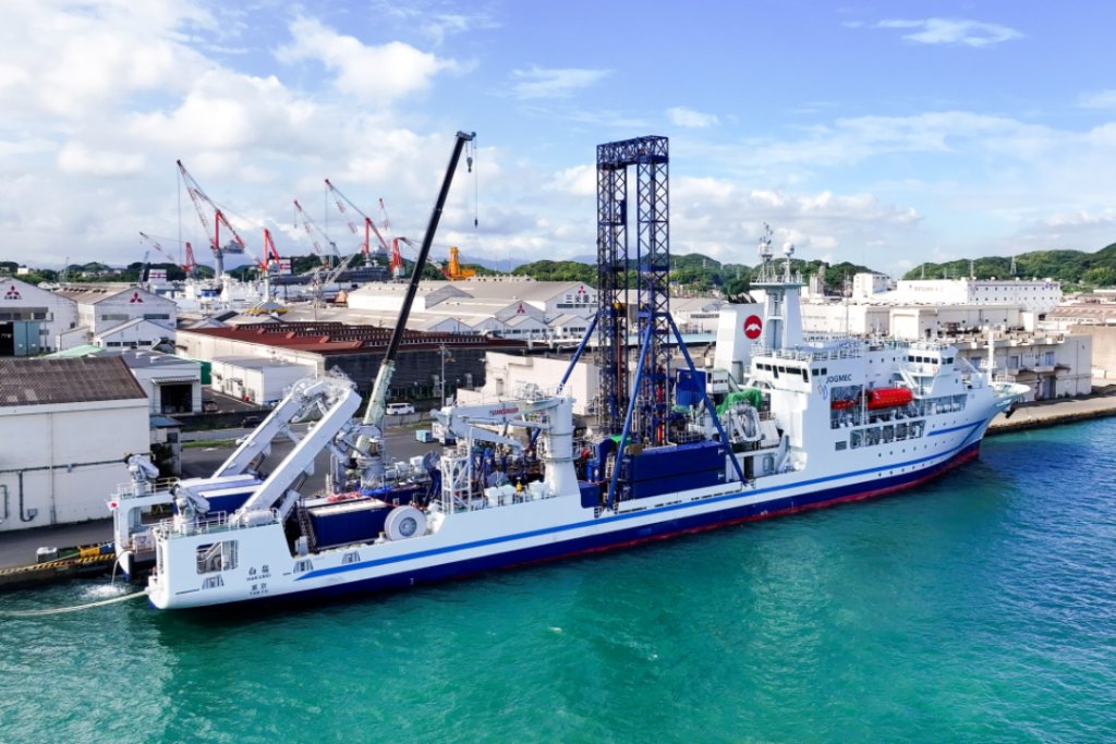
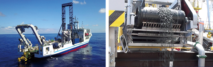
Oceanographic research vessel: “Hakurei”
In marine mineral resource development, resource assessment of the seabed, environmental baseline surveys, and establishment of production technology are essential.
JOGMEC manages and operates the “Hakurei” research vessel in the waters around Japan.
In September 2025, while the ship was docked at Shimonoseki Port, I was given a tour by Mr. Satoshi Shiokawa of JOGMEC’s Metal and Marine Resources Department.
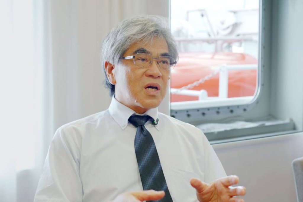
Mr. Shiokawa of JOGMEC:
“It’s a large ship, equivalent to six Yamanote Line train cars, and conducts offshore surveys for more than 270 days a year.”
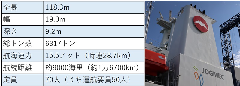
1. The Hakurei is 118.3m long, 19m wide, 9.2m deep, has 7 decks, and a gross tonnage of 6317 tons.
2. The hull cost 20 billion yen, the research equipment 7.5 billion yen, and the outfitting costs 2.4 billion yen, and it was built by Mitsubishi Heavy Industries.
3. It was deployed in February 2012, and the operation is handled by Marine Technology Development (headquarters in Tokyo).
According to Mr. Shiokawa, the ship carries a research team and conducts nine voyages a year, each lasting 30 days, completing 270 to 280 days of offshore surveys annually.
Overview and funnel mark of the Hakurei:
The biggest feature of the Hakurei as a research vessel is that it investigates “what kind of minerals, where, how much, and in what condition they exist” (Mr. Shiokawa).
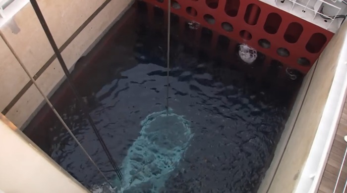
Symbols of the Hakurei: “Ship-mounted drilling rig” and “Moonpool”:
On the Hakurei, the living quarters and research laboratories are located at the bow, and the engine room and other facilities are located in the center of the hull.
A large research work deck equivalent to two tennis courts is secured at the stern. Equipped with various equipment depending on the survey content:
The Hakurei uses two types of large drilling rigs depending on the seabed and geological conditions.
The 35m “ship-mounted drilling rig” called “R140” can drill from the seabed at a depth of 2000m to 400m below the seabed.
A 35m high ship-mounted drilling rig is installed in the center of the hull, and a wide survey work deck is secured at the stern.
The most stable part of the hull: JOGMEC’s official YouTube account
1. A 7.5m square opening (moonpool) is provided, from the deck to the bottom of the ship.
2. Drilling pipes and survey equipment can be lowered into the sea.
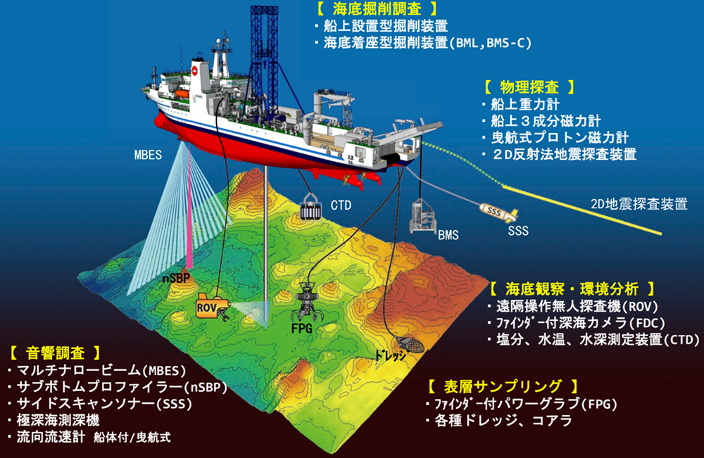
“Remotely Operated Vehicle (ROV)”: “Finder-equipped Power Grab (FPG)”:
In addition, seabed observation and material sampling can be performed by remote control from the ship.
3. An ROV and an FPG shaped like a crab’s claw are installed.
4. Sonar for acoustic surveys is also equipped. The collected samples are analyzed on the spot in the onboard laboratory.
![]()
Hakurei’s survey concept diagram and survey flow: DPS = Dynamic Positioning System
A DPS (Dynamic Positioning System) is essential for maintaining the ship’s position at a fixed point, and the Hakurei has no rudder.
1. The most difficult aspect of marine mineral resource surveys is detecting the effects of ocean currents, waves, and wind, and maintaining the ship’s mooring position at a fixed point.
2. In drilling surveys of seafloor hydrothermal deposits, if the ship’s position shifts, the pipe connecting the seabed and the ship will break.
This is where the “automatic ship position keeping device” comes into play.
3. Two “azimuth thrusters” that can rotate a huge propeller horizontally 360 degrees with the ship’s propulsion system.
4. The ship’s position is maintained at a fixed point by precisely controlling two fixed bow thrusters and one retractable thruster at the bow.
Therefore, even though the Hakurei has no rudder, it can adjust its position in units of tens of centimeters. Even after suspending mining operations and evacuating due to inclement weather or other reasons, there is no need to dig a new hole, allowing for efficient progress of the work.
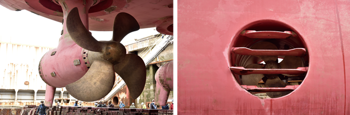
Aft azimuth thruster (left): Bow thruster near the bow:
Furthermore, the Hakurei, which also conducts acoustic surveys, minimizes the impact of noise and vibration generated from the ship.
1. The power for the azimuth thrusters and bow thrusters is entirely supplied by electricity generated by the engine.
2. When moving the ship, they have succeeded in suppressing noise to 60 dB or less.
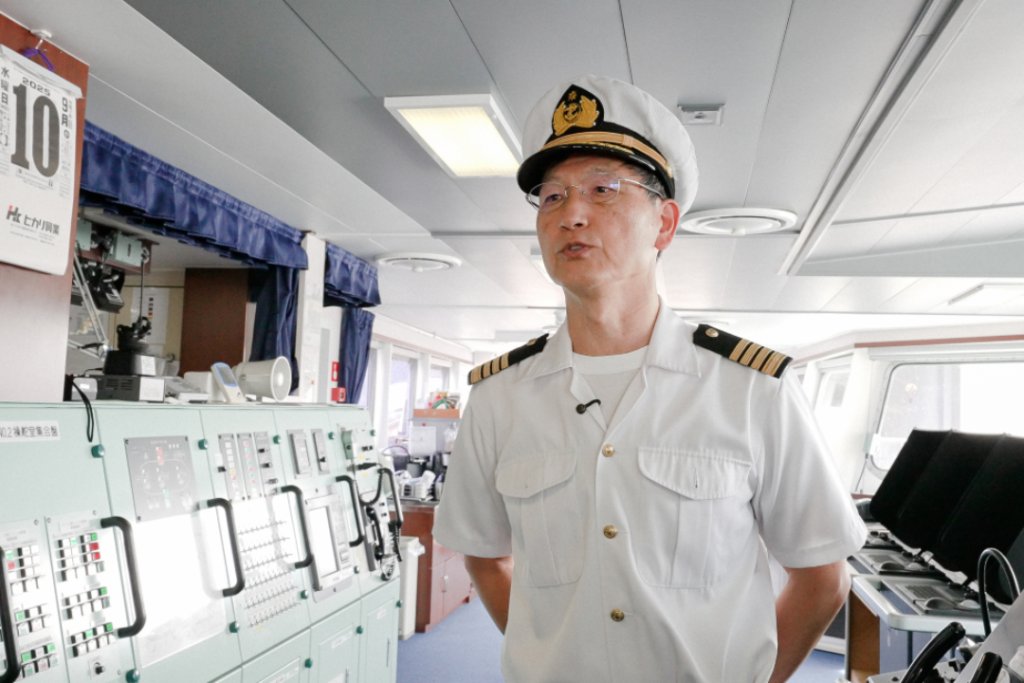
Captain Masashi Sato of the Hakurei:
“The Hakurei is a culmination of wisdom aimed at discovering ‘what kind of minerals, where, how much, and in what condition they are.'”
In 13 years, with 126 voyages and a total of 3649 days of research, they have discovered many mineral deposits.
1. One notable achievement is the successful continuous extraction of seafloor hydrothermal deposits in 2017.
2. They drilled a hydrothermal deposit at a depth of 1600 meters off the coast of Okinawa and continuously lifted the collected minerals to the surface using an underwater pump.
3. In 2020, they successfully mined cobalt-rich crusts within the EEZ south of Minamitorishima.