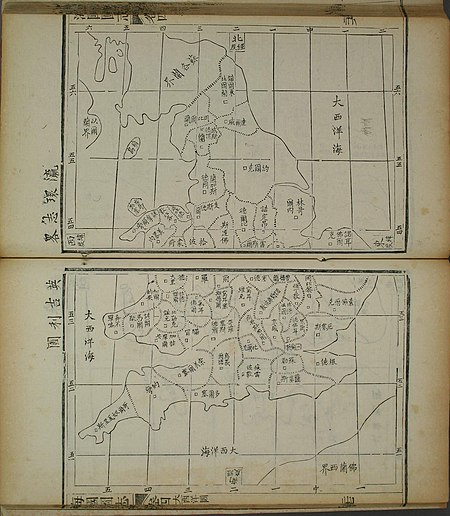
Map of England from the Hǎiguótúzhì
Japan: Learn the strong points of iteki、use them to defeat them: Teaching of Hǎiguótúzhì
Meiji Restoration in Japan:
Japan learned from ancient China as a teacher.
In China, many people think that the turning point between Japan and China lies in the “Meiji Restoration.”
Chinese media information:
On March 1st, an article was posted to support the Meiji Restoration and introduce that there is a “book that made Japan a powerful country in Asia.”
The author is Chinese.
Unfortunately, the work did not spread in China.
The work introduced in “Illustrated Treatise on the Sea” written by Wei Yuan , the Qing dynasty.
Teachings of “Illustrated Treatise on the Sea”:
Illustrated Treatise on the Sea introduces the geography of the world, Western technology and ideas.
“Learn the strong points 、use them to defeat them with it”:
In other words, by learning foreign advanced technology,
Insist on preventing aggression against your country,
He advocates the importance of learning abroad.
This geography book describes the advanced technology of the West.
China’s response:
This geography book is very useful for informing the people of the Qing dynasty about the outside world.
However, criticized that “the ruler the Qing dynasty banned the sea country map and took a fool policy.”
Japan’s response:
Japan responded in the exact opposite of Qing.
When Illustrated Treatise on the Sea entered Japan from China, it “caused a sensation in no time.”
Japan was surprised, “Is Japan like this in the outside world?”
Success of the Meiji Restoration:
Educate the Japanese people for westernization,
Get Western technology and equipment,
Using the compensation obtained in the Sino-Japanese War,
Thus Japan succeeded in the Meiji Restoration.
Differences in correspondence regarding the Illustrated Treatise of the Sea:
The Qing government’s failure is “a treat that China thought was the center of the world,” recalls the Qing dynasty article.
With this, admonished that “it would have been a matter of time before the Qing government would perish.”
The difference in the reaction between Japan and China over the sea nation map is a lesson in this era.
China-Searchina
http://news.searchina.net/id/1697390?page=1
Illustrated Treatise on the Maritime Kingdoms
The Illustrated Treatise on the Maritime Kingdoms, or Haiguo Tuzhi,
is a 19th-century Chinese gazetteer compiled by scholar-official Wei Yuan and others,
based on initial translations ordered by Special Imperial Commissioner Lin Zexu.
The Treatise
is regarded as the first significant Chinese work on the West[1] and one of China’s initial responses to the Anglo-Chinese First Opium War (1839–1842).[2]
Eventually stretching to one hundred juan, or scrolls,
the treatise contains numerous maps and much geographical detail covering both the western and eastern hemispheres.
Wei’s book
also garnered significant interest in Japan and helped mould the country’s foreign policy with respect to the West.
– Wikipedia
https://en.wikipedia.org/wiki/Illustrated_Treatise_on_the_Maritime_Kingdoms
Wei Yuan | Chinese historian |
In 1844 Wei published his best-known work, the Haiguo tuzhi (“Illustrated Gazetteer of the Countries Overseas”),
on the geography and material conditions of foreign nations.
Although handicapped by the ignorance and superstition with which the Chinese viewed the West,
this work was the first to make use of translations from Western sources. Wei proposed that the Chinese learn the superior technology of
the barbarians (in his day, Westerners seeking trading rights) so as to be strong enough to deal actively with their challenges.
This idea provided the justification for the reform of the Chinese state attempted in the 1860s and ’70s,
when its leaders finally began to introduce Western devices and technology into China.
Britannica