Indonesia: Afforestation with Japan quasi-zenith satellite “Michibiki”: Hitachi Solutions / Marubeni
September 13, 2019
Indonesia: Forest management
In Indonesia, UAV * 1 and a tractor are used together in a vast plantation to demonstrate quick and precise tree height measurement.
In the future, aim to improve the efficiency and accuracy of the logging plan.
Hitachi Solutions / Marubeni Corporation
The Ministry of Internal Affairs and Communications is undertaking a technical demonstration * 2 using the quasi-zenith satellite system “MICHIBIKI”.
Hitachi Solutions / Marubeni has demonstrated the applicability of high-precision positioning technology to a part of the vast plantation in Indonesia.
The test will be conducted for two months from September 2019.
Forest management system: logging planning
In this demonstration experiment, the latest forest management system will support the planning of logging and improve the measurement accuracy of tree height (tree height).
Hitachi Solutions:
Together with Marubeni and Hitachi, we improved the tree height measurement accuracy by utilizing the high-precision positioning technology by Michibiki.
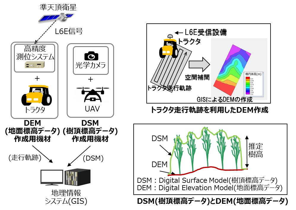
It consists of Hitachi’s high-precision positioning technology and Hitachi Solutions’ GeoMation * 3.
1) Mount the optical camera on the UAV and measure the height of the top of the tree.
2) A high-precision positioning signal receiver is installed in the tractor to measure the height of the ground (ground elevation).
3) By subtracting the ground elevation from the treetop elevation, the tree height is calculated for the entire plantation.
https://www.marubeni.com/jp/news/2019/release/20190913J.pdf#1568300400