JAXA | Satellite Global Precipitation Map (GSMaP) Service Expansion:
World Meteorological Organization (WMO):
We strengthened the data link between the weather forecasting service of the meteorological institutions in each country and the “JAXA” satellite global precipitation map (GSMaP).
JAXA: Satellite Global Precipitation Map (GSMaP)
Global precipitation observation plan (GPM) main satellite, providing high precision, global precipitation map GSMaP in near real time.
Integrated multiple satellite data based on dual frequency precipitation radar (DPR: GPM loading) data.
JAXA Global Rainfall Bulletin “:
Since November 2007, the website is being released as “JAXA Global Rainfall Bulletin”.
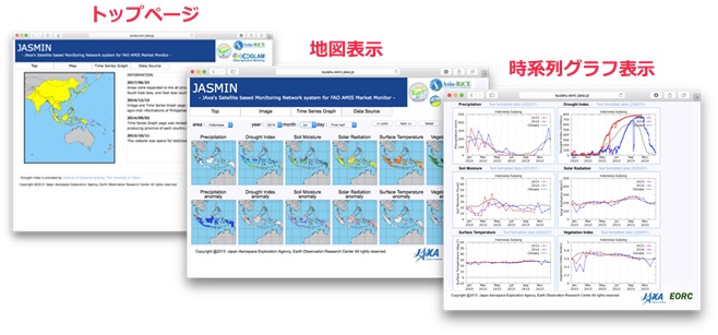
The use of GSMaP is advancing in various fields such as precipitation monitoring, flood forecasting, drought monitoring and agriculture.
Already, registered users using GSMaP data are 117 countries worldwide
It can be seen that 78% of registered users are from Asian countries, and that there is a particularly high level of interest in Asia, where there are many water disasters.