ALOS-3: Achievement of optical satellite communication!
-Mitsubishi Electric unveils advanced optical satellite-
Mitsubishi Electric:
September 22, 2022,
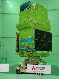
The body of the latest optical satellite “DAICHI-3 (ALOS-3)” was released to the media.
DAICHI-3 (ALOS-3):
Daichi 3 is
“DAICHI” (2006-2011) An earth observation satellite that takes over the optical mission (Fig. 1)
Equipped with a large, high-performance sensor:
Equipped with a large, high-performance sensor,
Observation width 70km,
A wide area with an observation distance of 4000 km,
Observation is performed with a high precision of 0.8 m ground resolution.
Collect geospatial information and monitor changes on the ground.
In the event of a disaster, earthquakes, floods,
Acquire the disaster situation such as eruption over a wide area.
Features of DAICHI-3
Higher resolution of captured images,
an increase in the observation wavelength band,
adoption of optical satellite communications,
Utilization in private business,
Conventional Daichi:
A black-and-white image sensor with ground resolution = 2.5 m,
It was equipped with a color image sensor with a ground resolution of 10m.
The new DAICHI-3:
A black-and-white image sensor with ground resolution = 0.8 m,
It is equipped with a color image sensor with a ground resolution of 3.2m.
Image sensor:
A CCD (charge-coupled device) is used, both of which were developed in-house by Mitsubishi Electric.
It has 24 sensors in total, 12 each for black and white and 12 for color (Fig. 2).
Nikkei Cross Tech (xTECH)
https://xtech.nikkei.com/atcl/nxt/column/18/01819/00020/
ALOS-3 : Réalisation de la communication optique par satellite !
-Mitsubishi Electric dévoile un satellite optique avancé-
Mitsubishi électrique :
22 septembre 2022,
Le corps du dernier satellite optique « DAICHI-3 (ALOS-3) » a été dévoilé aux médias.
DAICHI-3 (ALOS-3):
Daichi 3 est
« DAICHI » (2006-2011) Un satellite d’observation de la terre qui reprend la mission optique (Fig. 1)
Équipé d’un grand capteur performant :
Équipé d’un grand capteur performant,
Largeur d’observation 70km,
Une vaste zone avec une distance d’observation de 4000 km,
L’observation est effectuée avec une grande précision de résolution au sol de 0,8 m.
Collectez des informations géospatiales et surveillez les changements sur le terrain.
En cas de catastrophe, tremblements de terre, inondations,
Acquérir la situation de catastrophe telle qu’une éruption sur une vaste zone.
Caractéristiques du DAICHI-3
Meilleure résolution des images capturées,
une augmentation de la bande de longueur d’onde d’observation,
adoption des communications optiques par satellite,
Utilisation en entreprise privée,
Daichi conventionnel :
Un capteur d’image noir et blanc avec une résolution au sol = 2,5 m,
Il était équipé d’un capteur d’image couleur avec une résolution au sol de 10m.
Le nouveau DAICHI-3 :
Un capteur d’image noir et blanc avec une résolution au sol = 0,8 m,
Il est équipé d’un capteur d’image couleur avec une résolution au sol de 3,2 m.
Capteur d’images :
Un CCD (dispositif à couplage de charge) est utilisé, tous deux développés en interne par Mitsubishi Electric.
Il dispose de 24 capteurs au total, 12 chacun pour le noir et blanc et 12 pour la couleur (Fig. 2).
Nikkei CrossTech (xTECH)
ALOS-3: Errungenschaft der optischen Satellitenkommunikation!
-Mitsubishi Electric stellt fortschrittlichen optischen Satelliten vor-
Mitsubishi Electric:
22. September 2022,
Der Körper des neuesten optischen Satelliten “DAICHI-3 (ALOS-3)” wurde für die Medien freigegeben.
DAICHI-3 (ALOS-3):
Daichi 3 ist
„DAICHI“ (2006-2011) Ein Erdbeobachtungssatellit, der die optische Mission übernimmt (Abb. 1)
Ausgestattet mit einem großen, leistungsstarken Sensor:
Ausgestattet mit einem großen, leistungsstarken Sensor,
Beobachtungsbreite 70km,
Ein weites Gebiet mit einer Beobachtungsentfernung von 4000 km,
Die Beobachtung erfolgt mit einer hohen Präzision von 0,8 m Bodenauflösung.
Sammeln Sie Geodaten und überwachen Sie Veränderungen vor Ort.
Bei Katastrophen, Erdbeben, Überschwemmungen,
Erfassen Sie die Katastrophensituation, z. B. einen großflächigen Ausbruch.
Eigenschaften von DAICHI-3
Höhere Auflösung der aufgenommenen Bilder,
eine Zunahme des Beobachtungswellenlängenbands,
Einführung der optischen Satellitenkommunikation,
Nutzung im Privatgeschäft,
Herkömmlicher Daichi:
Ein Schwarz-Weiß-Bildsensor mit Bodenauflösung = 2,5 m,
Es war mit einem Farbbildsensor mit einer Bodenauflösung von 10 m ausgestattet.
Der neue DAICHI-3:
Ein Schwarz-Weiß-Bildsensor mit Bodenauflösung = 0,8 m,
Es ist mit einem Farbbildsensor mit einer Bodenauflösung von 3,2 m ausgestattet.
Bildsensor:
Zum Einsatz kommt ein CCD (Charge-Coupled Device), beides Eigenentwicklungen von Mitsubishi Electric.
Es verfügt über insgesamt 24 Sensoren, jeweils 12 für Schwarzweiß und 12 für Farbe (Abb. 2).
Nikkei Cross Tech (xTECH)