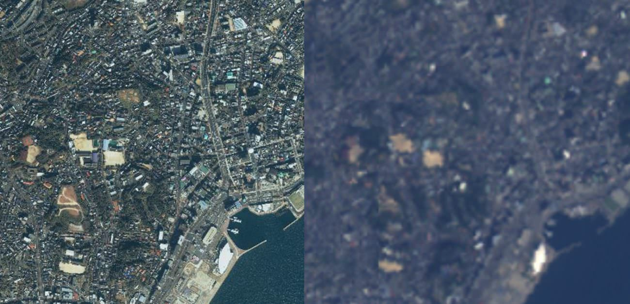
To the left: an IKONOS image (resolution: 3 m) and to the right: an AVNIR-2 image (resolution: 10 m). There is a difference in resolution of over three times between these, with different color variations.Credit : JAPAN SPACE IMAGING CORPORATION (left) JAXA (right)
Tellus:免费 Tellus-Clairvoyant:高分辨率卫星图像
-利用超分辨率技术“Tellus-Clairvoyant”-
Tellus-千里眼:
2021 年 10 月 21 日,我们开始免费提供软件。
该工具由 Sakura Internet 与夏普公司合作开发,利用超分辨率技术。
锋利的
樱花互联网
使用深度学习模型执行超分辨率处理。
在AVNIR-2和PALSAR-2的卫星数据中,
双倍或四倍分辨率,
我能够以伪方式扩展它。
樱花网:
与夏普合作
提高卫星数据的可见性
开发卫星数据超分辨率技术,
这一次,我们提供了一个工具。
航天工业:
近期,政府卫星数据的发布正在进行中。
但是,免费发布的政府卫星数据的分辨率只有10m左右。
新闻与话题|得力
使用夏普原创深度学习模型对卫星图像进行超分辨率处理 | Sorahata
Super-Resolution Processing of Satellite Images Using Sharp’s Deep Learning Model
The Sharp Corporation
is a participant in the xData Alliance, working together with Sakura Internet to make progress in satellite data application.
This article looks at satellite super-resolution imagery made with machine learning as a part of the framework for the alliance.
Super-resolution is a technique to artificially raise the resolution of an image.
Super-resolution
is one of the hot topics in the field of machine learning, but what happens when you combine it with satellite imagery?
We went to the Sharp Corporation (referred to below as “Sharp”) Research and Development HQ,
asked the manager of the 3rd Research Team for Communication & Image Technology Laboratories,
Tomohiro Ikai, and researcher, Eiichi Sasaki about the future of this technology.
Sorabatake
https://sorabatake.jp/en/12973/
【Tellus-Clairvoyant(ADIN)】
【Tellus-Clairvoyant(API)】